 Visiting Salatiga is always good. It gives me a sense of excitement, friendship, purpose, innovative thoughts, and voluntary drives.
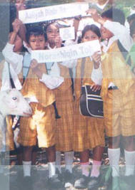
First we didn’t really plan to come over to Bahrudin’s school. But I’m glad that we did. The SMP kids are awesome & adorable. Gue ge-er berat that they still remember my name! And they’re growing to be good looking kids. The kind of good looking that comes from the inside, from self-confidence, from ability to present one’s ideas, and from being spontaneous and real.
Pak Ahmad, Pak Jono, all greeted me with the kind of warm smiles that true friends give. The The topic of the day was geography. The previous day I led an “intro to GIS for social development purposes” discussion at the office. Isn’t GIS amazing? Just a couple of hours of discussion and new ideas are piling up. I told Bahrudin about Combine’s plan to develop the Federation’s database into a GIS-based format. All of a sudden we’re talking about teaching mapping to middle school kids. Bahrudin wanted the kids to take Kalibening as their main source of case study, so that in the future they’ll always contribute to the community. We’re going to make a model of the village. Ira said she’ll teach the kids model-making. Spatial awareness building for middle school kids; exciting!
Then we went to Ngawen, where the Farmer Federation office is located, to talk to Ruth & friends. Now, that is an organization with vision! As for their data, I’d bet they have more & data of members than any political party in Indonesia. Combine’s going to help them structure this data to their needs & dreams, and connect that to a GIS system. The output: a farmer federation with strategic information within easy reach of their fingertips!
 technorati tags: community, empowerment, geography, ICT, information
No comments:
Post a Comment